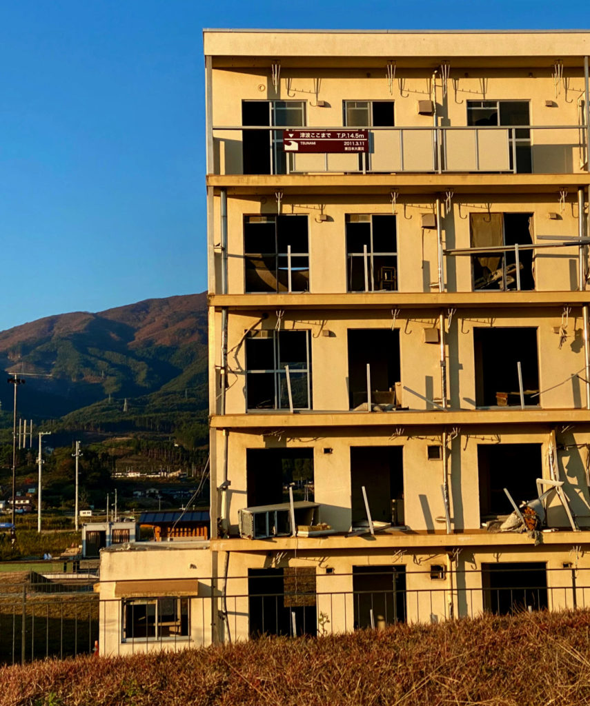
I had my first glimpse of the tsunami’s destruction three years ago, when I rode my bike along the northeastern coast of Japan’s main island. Below a snaking seawall was a wide swath of barren fields and muddy marshes. The raw landscape was punctuated by the gutted remains of a five-story residential building. On its side was a red line that marked the highest level reached by the tsunami’s floodwaters: 14.5 meters (48 feet).
![]() Japan’s 2011 tsunami killed some 20,000 people and left thousands more to dig their way out of the mud. Triggered by one of the most powerful earthquakes recorded in modern times, the overpowering tidal wave devastated the country’s northeastern region of Tōhoku across three prefectures. It also caused the meltdown of the Fukushima Daiichi nuclear reactor, prompting the evacuation of hundreds of thousands of residents. Most of the deaths and damage occurred along the Sanriku Coast just to the north. When I first visited Rikuzentakata, one of Sanriku’s hardest-hit cities, I was shocked by how visible the scars still were.
Japan’s 2011 tsunami killed some 20,000 people and left thousands more to dig their way out of the mud. Triggered by one of the most powerful earthquakes recorded in modern times, the overpowering tidal wave devastated the country’s northeastern region of Tōhoku across three prefectures. It also caused the meltdown of the Fukushima Daiichi nuclear reactor, prompting the evacuation of hundreds of thousands of residents. Most of the deaths and damage occurred along the Sanriku Coast just to the north. When I first visited Rikuzentakata, one of Sanriku’s hardest-hit cities, I was shocked by how visible the scars still were.
At the end of last year, I returned to Rikuzentakata for the Tour de Sanriku, a bicycle ride along the Hirota peninsula that the city has put on since the summer of 2011. Japan has plenty of cycle routes that are more scenic and in much more accessible locations, but like so many others, I wanted to commemorate the ten-year anniversary of the March 11, 2011 tsunami—commonly referred to as “3.11”—and see how the recovery was going.
Before 3.11, Rikuzentakata was a sleepy coastal city in the remote mountains of Iwate prefecture. Its downtown was centered on the harborfront along the Takata Matsubara sandbank, home to a lush, centuries-old forest of some 70,000 pine trees. That downtown and that forest were utterly wiped out by the tsunami, which also claimed the lives of some 1,500 residents.
I felt a surge of emotion when I arrived in Rikuzentakata for the second time. Two years later, it was surprising to see how little had changed. A tentative new city center was budding—relocated to higher ground—but the razed waterfront remained just as desolate. On one side of Route 45 was a new sports and recreation park with baseball fields and green spaces; on the other, construction machinery and signage stood conspicuously in marshlands inhabited by wild birds. Perpendicular to the shore, a wide, newly paved evacuation road led straight up into the mountains.
The ride began with one minute of silence. As every year, the mayor of Rikuzentakata, Futoshi Toba, presided over the ceremony. One month before the tsunami struck, Toba had been elected to his first term as mayor. At home on that day, his wife was swept away in the floods, as was their home; his two young sons, at school, survived.
The cyclists assembled in the sports park at the foot of the mountains. We wore numbered paper bibs with handwritten words of support for the local residents. Groups of riders set off in staggered starts, beginning with those who were making an extra loop around the mountain and passing by the neighboring town of Ofunato, also hit hard on 3.11. My course was 45 kilometers (28 miles), mostly along the scenic rolling coast of the Hirota peninsula.
Along the route, residents waved to us from their houses. They seemed to appreciate that cyclists had come from far-off Tokyo and elsewhere to be part of the commemoration. At rest stops, volunteers handed out generous snacks—homemade cookies stuffed with local fruit paste, juicy raw oysters fresh from the port.
Memorials for 3.11 dot Tōhoku’s eastern coastline, and a few were visible along our route. Over the past decade, the region has established a number of museums and parks to recognize the massive toll of the disaster, where volunteers from a number of local associations tell their personal stories of surviving the tsunami. These varied testaments to 3.11’s devastation are powerful, and yet equally affecting can be the signs of resilience—older trees and edifices that the tsunami left unharmed, inexplicably, to still stand on lone and level fields.
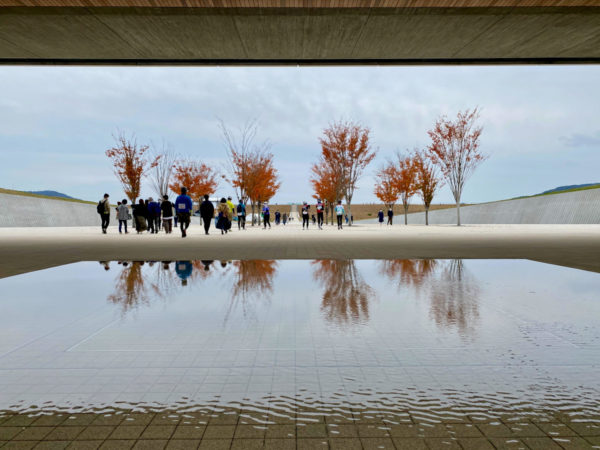
By midday, we cyclists rolled back along Route 45 to Hirota Bay, where we concluded the Tour de Sanriku with a pilgrimage walk through Takatamatsubara Memorial Park. The path took us past the Tsunami Memorial Museum and the roadside station, all the way down to the edge of the coast and the seawall lined with newly planted pine sprouts. Nearby was the wreckage of a youth hostel crumpled by the wave, and right in front of it, the preserved remains of the single pine tree that had survived the tsunami’s initial impact.
My attention was drawn to a peregrine falcon perched on one of the many uprooted stumps left preserved in the mud. When I looked back, I saw a woman high up on the seawall, laying a bouquet of flowers on a commemorative stone.

In the decade since the tsunami, communities all along the coast of Tōhoku have found their own ways to remember and recover. Further south in Ishinomaki, where almost 4,000 people died, a dedicated team of women is transforming shards of broken dishware and pottery into precious pieces of jewelry. The raging floodwaters destroyed more than two-thirds of the buildings in Onagawa, a town just to the east, but while most cities reacted to 3.11 by building longer, higher seawalls, Onagawa constructed a red-brick seafront promenade featuring artisanal shops and a new, entirely redesigned train station with an observation deck.
The day after the bike ride in Rikuzentakata, I went to the neighboring city of Kesennuma, nestled in a deep rias that had been thoroughly inundated in 2011. Arriving in the late afternoon, I cycled around the central harbor. The commercial area was newly rebuilt, with trendy pop-up shops and a sparkling multilevel community center. Prominently displayed in the center’s lobby was a meticulously crafted model of the neighborhood as it stood pre-March 11, 2011. Transparent flags bearing the family name of each household or shop indicated buildings that had been annihilated by the tsunami. I had seen models like this everywhere along the Sanriku Coast—simple markers of the region’s collective healing.
The next morning, I was excited to ride down the coastline to Kesennuma’s Sanriku Fukkō National Park, one of many parklands designated after 3.11 to promote the area’s recovery. But it turned out that Google Maps was out of date—the entire coastal route from central Kesennuma to Cape Iwai was blocked off, as it was still being rebuilt. Taking an inland detour through the hills, I biked along gravel roads and past forests, fields, and rural homes. At one point, I passed by a group of elementary school kids playing outside during recess; in another neighborhood, a public sign planted on the roadside read: “Don’t lose your temper, take a breath and relax.”
After an hour and a half, I finally rolled back down to the coast. A banner above an intersection announced that I was about to enter the national recovery park. As I rounded the corner and glimpsed the seaside, I stopped suddenly, in shock. Before me were the remnants of a four-story concrete school building, a huge hole ripped into its outer wall—as if Godzilla had taken a bite out of it.
This was Koyo High School, destroyed in the tsunami but left to stand, unrazed—preserved in its decrepitude as meticulously as Hiroshima’s Atomic Bomb Dome. Now part of the Great East Japan Earthquake Kesennuma City Memorial Museum, the ruins featured explanatory panels with context and testimonies about the disaster. The open fields around the school had been converted into a dog run, children’s playground, and miniature golf course. As I stood surveying the ruins, two young women walked by with a playful Shiba Inu, then disappeared into the nearby dunes in the mid-afternoon.
I followed a narrow road surrounded by fenced-off pine tree sprouts. Soon I came to a park on the edge of Kesennuma Bay. The seawall tapered off at the tip of Cape Iwai, ending at a small lawn with a walkway and benches. I sat down facing the craggy rocks at the cape’s end, watching as the waves battered them, flinging roaring jets of seawater into the air. Those rocks, I later learned, have been officially designated as a protected natural monument because of the Paleozoic fossils of coral and other ancient life they contain.
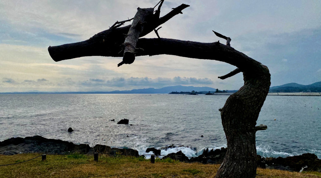
On the edge of the shore I spied the unmistakable silhouette of Kesennuma’s “dragon pine,” another hardy tree that survived the tsunami. Its leaves and branches had been violently stripped away, but its twisted trunk remained, looking uncannily like a whiskered dragon craning its neck to gaze at the ocean. Locals see it as a symbol of resilience.
Just as I stood up to leave, three older Japanese ladies approached the viewing bench, marveling at the waves crashing against the rocks. I smiled at them, as we all turned to face the ocean together.
 Republication allowed: This content has been published under a Creative Commons Attribution/No Derivatives license (CC BY-ND). You can republish it for free so long as you follow our guidelines.
Cherise Fong Cherise Fong is a bicycle traveler, writer, and journalist currently based in Japan.
- Follow us on Twitter: @inthefray
- Comment on stories or like us on Facebook
- Subscribe to our free email newsletter
- Send us your writing, photography, or artwork
- Republish our Creative Commons-licensed content